Using models and real time data, they are able to produce forecasts for areas in a 2.5 km area (that is about 1.5 mile). These forecasts include temperature, dew point, wind speed and direction, sky coverage (clouds), precipitation potential, relative humidity and more. You simply click on the location on a map for location and a page is generated with lots of information.
Today, after I went through the NWS Raleigh web page, I was interested in finding out what the wind speed, rain potential and low temperatures are expected this Saturday Sept 16 at 6 PM at the Carter-Finley Stadium in Raleigh (where NCSU is playing South Alabama).
First I went to http://www.weather.gov/ and saw the page below: I clicked on central NC...
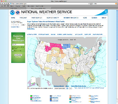
Then I clicked on the dot near Raleigh:

And this screen appeared :

Then in the above page, just off the screen above on the bottom right corner, there was a box titled "Hourly Weather Graph" I clicked on it and saw:

Viola! Looks like it will be 79 F at kick off, then cool off once the sun goes down (the image is fuzzy here, but is clear on the original site). The winds will be from the NE at 6 mph, very low chance of rain. So, it sounds like a very nice evening for a football game.
The folks at the NWS say that they are fairly confident with forecasts 6 hours from the current time. Also, in the western parts of the state of NC, there will be more variability in the accuracy of the forecasts for a particular site.
Now think how this may be of use in the spring when your buds are breaking and you need to know if there may be damage in the upcoming nights. Will you have time to implement some type of protection for your crop? How much wind is expected, how fast will those temperature drop? Will there be cloud cover? They update this information every 3-4 hours, 24 hours a day.
We will be using this site to help us determine if we should lay down our trellises and put on row covers in our blackberry trials at the Piedmont Research Station. See earlier post on that trial: http://teamrubus.blogspot.com/2012/05/rotating-cross-arm-trellis.html

